MENU

01/02/22 – Mapping the Sea Floor

Did You Know…about 56% of the Earth’s surface remains unmapped! That area corresponds to 80% of the ocean floor. Amazing to think that we know more about the surface of the moon — and we had the surface of Mars completely mapped back in 1999! — than we do about our own planet. The Nippon Foundation – GEBCO Seabed 2030 Project aims to map ALL of Earth’s ocean floor by the year 2030. Their mission: “to empower the world to make policy decisions, use the ocean sustainably and undertake scientific research based on detailed bathymetric information of the Earth’s seabed.” The shape and terrain of the ocean’s surface is critical to understanding circulation patterns which affect climate, weather patterns, tides, water action sediment transport, tsunami wave propagation and underwater plates and vents.   Learn more at BigThink.com and Seabed2030.org
Read More ›

Webster Lake – 03/16/21

“Webster Lake in located in south central Massachusetts, near the border of Connecticut and Rhode Island. It was formed by the retreat of glaciers during the last ice age and is replenished from streams and underwater springs. The lake rather shallow (only 13 feet on average) and is made up of three smaller bodies of water named North Pond, Middle Pond and South Pond. all joined by narrow channels.” [Source: DiscoverCentralMA.org]  It is not only the largest natural lake in Massachusetts, it is perhaps even better known as having the longest place name in the United States: Chargoggagoggmanchauggagoggchaubunagungamaugg, which comes from Loup, an Algonquian language, which roughly translates to, “Fishing Place at the Boundaries—Neutral Meeting Grounds.”  
Read More ›

Tribute to Marie Tharp – 03/08/21

On this International Women’s Day 2021, I’d like to pay special tribute to a mapping legend, one of the world’s greatest cartographers and oceanographers whom you’ve never heard of: Marie Tharp. “Before the early 1950s, scientists knew very little about the structure of the ocean floor. Though studying geology on land was cheaper and easier, understanding the structure of the entire earth could not be accomplished without knowledge of the structure and evolution of the seafloor. In 1952, Tharp painstakingly aligned underwater sounding profiles to create a total of approximately six profiles stretching west-to-east across the North Atlantic. From these profiles, she was able to examine the bathymetry (elevation of the sea floor) of the northern sections of the Mid-Atlantic Ridge. Tharp identified an aligned, v-shaped structure running continuously through the axis of the ridge and believed that it may be a rift valley. She believed that the rift valley formed by the oceanic surface being pulled apart. Her idea would have supported continental drift, then a controversial theory. At the time many scientists believed that continental drift was impossible. Though her proposal was dismissed as “girl talk”, Tharp persisted and eventually the scientific community was persuaded to her ideas.” […]
Read More ›

Mining Maps – 11/16/20

One of the driving motivations of the settlement of the American West was mining. The gold, silver, copper, lead and other minerals attracted fortune seekers from around the world. Beginning in the late 1850s, prospectors flocked to Colorado, Utah, Nevada and of course, California. But it wasn’t just the West that was mined, nearly every state east of the Mississippi also saw prospectors for coal and oil. As government organizations helped settle the lawlessness of the mining districts, the need to accurately determine who had the rights to particular plots of land became necessary. At first, maps played an integral part of resolving who owned what; they also included distances, railroads, and telegraph lines. Maps were the only way to show deposit names, owners and locations. Later maps were used by people and companies to flaunt their claims and potential for resources and riches. Mining maps also served to show safety and workings features of mines. Some of the original handmade maps are very intricate and colorful, literal works of art. I recently stumbled across an old mining map of the Comstock Lode and was struck by its beauty. After a little “digging” on the web I unearthed a treasure trove […]
Read More ›

Tropical Storms of 2020 – 11/08/20

This year has been extraordinary for so many reasons, not least of which for the extreme wildland fires that has occurred in the American West and the number of severe storms in the tropics throughout the world. These first three maps show the tracks and intensity of hurricanes in the Atlantic Ocean, typhoons in the Pacific Ocean and cyclones in the Indian Ocean (those names are not interchangeable but the storms themselves are essentially identical). The points show the location of each storm at 6-hour intervals. The color represents the storm’s maximum sustained wind speeds as classified in the Saffir-Simpson Hurricane Scale, and the shape of the data points represent the type of the storm. [Source: Wikipedia] The second map shows the cumulative tracks of tropical storms from 1985 to 2005. The maps are from Wikipedia and were created using WikiProject Tropical cyclones/Tracks. The background image is from NASA. The tracking data is from the National Hurricane Center’s Atlantic hurricane database
Read More ›

Mapping Wildfires – 07/0/8/20

I recently landed a new project that involved illustrating an Incident Command System at a typical wildland firefighting base. I was rally fired up about the project, but because it was so detailed and specific I needed to do a fair bit of research before I could begin drawing. To help light a fire under me I became acquainted with wildland firefighting in general. I watched the 2017 movie Only the Brave, based on the true story of the 2013 tragedy where 19 of 20 Granite Mountain Hotshots perished in the Yarnell Hill Fire. I watched a number of online documentaries of some of the most infamous fires in U.S. history (such as Camp Fire of 2018, Valley Fire of 2015, Yellowstone Fire of 1988m, South Canyon Fire of 1994, Thirtymile Fire of 2001) and burned through the books Granite Mountain by Brendan McDounough and Smokejumpers by Jason A. Ramos. All of my self-education really put a fire in my belly to me to make my illustration as accurate and educational as possible. One of the most important aspects of wildland firefighting is how critical mapping fires is to the safety of the personnel and the success of the mission. […]
Read More ›

River Maps of William Nealy – 05/29/20

“Well-known among paddlers for his instructional books, stories and river maps, William Nealy passed away July 19, 2001 at the age of 47. Nealy brought a self deprecating sense of humor and a wealth of practical knowledge to all his work. His river maps are still posted prominently at Southeastern rafting companies for the benefit of both customers and guides, and served to guide many kayakers and canoeists on their maiden voyages. William Nealy was a one of a kind, loved in the paddling community and will be missed.” [Source: AmercianWhitewater.org] “He began by drawing river maps of popular southeast runs, and in 1986 dropped Kayak: A Manual of Technique (Menasha Ridge Press), which for my money is still the best book ever written on the subject.” [Source: WhitewaterHistory.com]
Read More ›

First Hiking Trail Map – 04/28/20

In France, just south of Paris, is the town of Fontainebleau. And at its heart lies the namesake 12th century chateau, an opulent 1,500-room home built by French royalty. Its proximity both to Paris and to the surrounding forests rich in deer and wild boar made it a popular hunting ground and vacation home. In the 17th century, Louis XIV greatly expanded the size of the forest by large-scale plantings of oaks, beeches and pines. It was enlarged again in 1983 and today covers more than 50,000 acres (an area roughly three times the size of Manhattan). In 1832, a 44-year old veteran of the Napoleonic Army by the name of Claude-François Denecourt decided to walk into the Forest of Fontainebleau in hopes of comforting his mind to cope with depression. He discovered an immense pleasure by wandering amongst the forest’s rocky outcroppings and root-studded earth. From that moment on he devoted himself entirely to developing and promoting the forest as a destination for the general public. They became known as “excursionists” and were the world’s first hikers and nature tourists. Today he is recognized and appreciated as a clever entrepreneur — he wrote and published his own travel guides […]
Read More ›

Voyages of Capt Cook – 04/15/20

I have always wanted to try creating a font. I always thought it would be a fun and fabulous thing to do, to use on my maps or just to know what the process is like. So for my first attempt I took inspiration from — you guessed it — a map! In 2019 I toured the Special Collections Room in the American Geographical Society Library (located on the campus of the University of Wisconsin-Milwaukee). During my visit I marveled at the sketching and lettering style on some original maps by James Cook (you can view digitized versions of them here). I immediately thought his handwriting would make for a wonderful font. So I traced some of his letters using Adobe Illustrator and used Calligrahr to build a simple font family I named “Capt Cook” (there already exists a font called Captain Cook, it’s a tattoo font by Graphic River inspired by Cook’s encounters with the tattooed indigenous peoples of the South Pacific. FACT: James Cook was a naval captain, navigator and explorer who, in 1770, charted New Zealand and the Great Barrier Reef of Australia on his ship HMS Endeavour. He later disproved the existence of Terra Australis, a […]
Read More ›

Get Lost in a Map? 4/4/20

How does one “get lost” looking at a map? “Maps can help viewers get their bearings and the lay of the land, or transport them into a realm of pure fantasy. A viewer might find a quiet thrill in poring over a map of a place they already know, or divert themselves by looking at a map that’s ‘just fun and complex, with lots of things going on,’ says Matthew Edney, a scholar of cartography at the University of Southern Maine. ‘And it’s easier to get lost within a detailed map of [a] place—one that shows features at a human scale, to which we can relate, so that we can imagine being inside the landscape.’ [Source: AtlasObscura.com]
Read More ›

2/27/20 – If Tolkien Had Drawn Maps of the National Parks

Fans of J.R.R. Tolkien’s Lord of the Rings trilogy or The Chronicles of Narnia series by C.S. Lewis will no doubt recognize the map artistry of Pauline Baynes (1922-2008). While Tolkien and his son Christopher drew some of the maps for the books, Baynes was the only other artist approved by Tolkien to illustrate the maps for his books. Since then, many others have copies or imitated that style to reproduce the lands of Middle Earth. That particularly recognizable pointillistic style of pen and ink — depicting wild landscapes full of imposing mountain ranges and impenetrable forests — seems to evoke the imagination like no other. One artist, Dan Bell, has been having fun reimagining that style of Tolkien to create maps of real places, in Europe and North America. You can view them, and purchase prints, on his website, MiddleEarthMaps.com. Recently Backpacker magazine commissioned Bell to create a few maps of national parks, like Everglades and Great Smoky Mountains. Check them out here!
Read More ›

Mapping with Type – 1/24/20

Illustrated maps are typically designed by using small icons, images or graphics to depict landforms, buildings, people and objects. But some mapmakers choose instead to use only type, and color. Such maps can be an extra challenge to create, as the individual words and letters often need to be turned, tilted, warped or otherwise manipulated to fit the shape of towns, states, counties and entire countries. The artist may use a single typeface or a mix of various fonts. The effect is intriguing and visually eye-catching!
Read More ›

Food Maps – 1/22/20

Gastronomy can be defined as the study of the relationship between food and culture, the art of preparing and serving rich or delicate and appetizing food, the cooking styles of particular regions, and the science of good eating. [Wikipedia]. Though origins of gastronomy back to the French reign of Louis XIV, the term can be used for any country or region. The classic art of carte gastronomique — a map summarizing a country by its locally sourced food products — dates back to a delicately illustrated map from 1809. It depicts the various cheese, sausage, livestock, fish and wine from various regions in France. Read more about it here on AtlasObscura. Though France may be the most popular country to be represented by gastronomic maps, it is definitely not the only one. Since 1809, mapmakers around the world still use maps to great effect, to show off the culinary delights of countries, states, cities, towns and even neighborhoods. Today these kinds of maps are more popularly called foodie maps, culinary maps, food tour maps or food trail maps; the same kinds of maps are also used for drinks like beer and wine. I recently created this map of Milwaukee’s most famous frozen custard stands. What better way […]
Read More ›

A Street Map of Hollywood Movies – 1/20/20

The Dorothy Collective has released an updated version their 2012 imaginary Los Angeles street map, titled “Film Map,” labeled with over 900 popular movie titles like the Oscar winning La La Land and Manchester by the Sea.” Prints are available to purchase from the Dorothy shop. The map, which is loosely based on the style of a vintage Los Angeles street map, has its own Hollywood Boulevard and includes districts dedicated to Hitchcock and Cult British Horror movies. There are parks (Gorky Park, Jurassic Park and Soylent Green) and islands (Shutter Island, Isle of Dogs and Treasure Island) and houses (House of Dracula, Big Momma’s House and Home Alone) and water (Mystic River, Reservoir Dogs and On Golden Pond). Like most cities it also has its own Red Light area. There’s an A-Z key at the base of the Map listing all the films featured with their release dates and names of the directors. It’s an imaginative way to celebrate film, and would make a great gift for the movie buff in your life!
Read More ›

The Witcher Interactive Timeline Map – 1/16/20

Maps are an incredibly engaging way to help tell a story. Have you seen the Netflix fantasy series The Witcher yet? It is based on a series of books by Polish author Andrzej Sapkowski (now a half-million copies are being reprinted to keep up with readers’ demand). It follows the exploits of a monster-hunter named Geralt of Rivia, played by Superman Henry Cavill. The first season jumps between three different timeliness (a technique inspired by the WWII movie Dunkirk), making it rather maddening to follow the chronology. Netflix knows this and has graciously created a delightful interactive fantasy map to help you sort things out. The Witcher’s Map of the Continent website is a perfect example of how to bring different media together to create a compelling storytelling experience. The site uses subtle and smart UI animations to engage users, and give them the information they need to better understand the order of events. It borrows from well-known everyday elements (like Google Maps) to ensure an intuitive and vastly enjoyable experience. Click on the timeline ribbon at the bottom (or drag the marker left or right to follow the timeline) and the map window moves around to the exact location […]
Read More ›

Train & Railway Maps – 1/15/20

If you love maps and trains, you will no doubt love Mark Ovenden’s book Railway Maps of the World (Penguin Group 2011). It is “an irresistible compendium of historical and contemporary railway maps and posters from every corner of the world. Hundreds of images, covering two centures of advertising, surveyors’ maps, travel posters and photos, are enhanced by a text brimming with vivid historical details and charming anecdotes.” It’s a fascinating read, and every page reveals interesting things I never knew before! For example, I learned how the railroads literally created time as we know it, as well as the concept of time zones…and how Cuba became the first Latin American country to get a railroad (and was the 6th in the world to do so! The Cuban railway was originally built by the Spanish as a means to transport sugarcane to the ports, which is interesting since Spain had yet to build a railroad in its own country at that point.) Want more train and railway maps? Check out Trains.com, a site for everything trains by Kalmbach Media (headquartered in my own backyard, just outside Milwaukee). “Trains magazine’s collection of railroad maps is unique in its appeal to serious […]
Read More ›

Google Maps, Solar System Edition – 1/11/20

Google Maps lets you travel effortlessly around planet Earth, we all know that. You can view just about any location on the globe in Street View, or Satellite View. But did you know that you can also zip around the Solar System via simulated hyperspace to similarly view planets and moods? Check out Venus, Ganymede or even Pluto! Using your mouse you can revolve each one to view various named craters and other landforms. Try it yourself, here’s how (I believe it only works right now using Google Chrome): Go to Google Maps. Click the “Satellite view” button at the lower-left of the screen. Click the super-tiny “Global view” button at the top of the navigation controls in your browser’s lower-right corner. Using either the “-” key, your mouse wheel, or the Google Maps zoom controls, zoom out until you’re in the planetary view of Earth. Select one of the various planets and moons from the list on the left, and you’ll blast through hyperspace to your new destination. Eligible destinations include Mars (to visit Dr. Manhattan), Europa (to recreate the journey of that 2013 sci-fi film), and the International Space Station (to say hello to everyone currently zooming around our planet). [Source: LifeHacker.com]
Read More ›

Viva Cuba! 12/31/19

I recently returned from a whirlwind trip to Cuba, and let me tell you what a magnificent adventure it was! The people, the countryside, the history, the architecture, the food…it was all so overwhelming beautiful! I am already anxious to plan my return trip…this was my first trip and I had but a taste of all Cuba has to offer! While I walked the streets of Havana and hiked the forests of Vinales, I was always on the lookout for maps. I was not disappointed! I found maps everywhere I went…from tourist map boards to maps of city streets and rural hiking routes to vintage colonial maps to a huge decorative 3D map behind the reception desk at a hotel. My visit to this Caribbean wonderland has inspired me in so many ways, I can’t wait to create some new maps of Cuba!
Read More ›

Maps + Coffee = Love – 12/5/19

What if I told you there was a place you could go to enjoy a great cup of coffee, a delicious breakfast croissant or pastry, live music…and maps! Well I found such a place in Madison, Wisconsin. It’s called Cargo Coffee and they rock! They are a family-owned coffee shop that roasts their own coffee weekly, serves a variety of breakfast croissants and pastries, and has a fresh made-to-order lunch menu. I had never been there before, but what a pleasant surprise it was! First off, I just love the logo of the vintage plane (is it a Douglas DC-3?)…although I think it would look even better with a map in the background! Second, as soon as I walked inside I was struck by the huge wall world map mural — so cool! Then, as I walked in toward the counter in the back I saw more maps on the walls, as well as a variety of vintage globes. Upstairs they have a framed display of vintage airline stickers on the wall, and beside that was a super cool illuminated globe on a stand that looks like the plane in the logo! I like the vibe of this place, it […]
Read More ›

Replogle Globes – 11/25/19

I recently found this 12″ antique illuminated globe with relief left for trash at the curb near my home. I took a closer look and discovered it was in very good condition (and the bulb even works)! After some minor surface cleaning it’s pretty much good as new! I remember having a globe in my room as a kid, but never one that lit up or was set in a wood stand like this. What wonderful luck to stumble upon this authentic Replogle Globe! Backstory: Chicago salesman Luther Replogle was a true visionary. In the late 1920s, he sold supplies, including globes, to schools. Replogle was convinced that information-hungry Americans would eagerly buy globes for their homes so they could pinpoint places they heard about in the news. His credo was “A globe in every home.” So in 1930, in the depths of the Great Depression, Luther quit his job and borrowed $500 from friends and family to start Replogle Globes. His wife, Elizabeth, and one employee made the cardboard and plaster globes in their basement and Luther sold them from his Model T Ford. Sales were very slow, understandably, until he got his big break in 1933: he designed […]
Read More ›

World Map at Lake Klejtrup – 11/22/19

In 1943, Danish farmer Søren Poulsen was working on the drainage of his land when he found a stone shaped like Jutland. That stone inspired him to create a small world of his own. During the winter months he placed big stones carefully on the ice and when spring arrived they could easily be tilted into place, and slowly (over the course of 25 years) he ultimately created what is now the World Map at Lake Klejtrup. This miniature world map is walkable, built of soil, stones, and grass, and covers about 1 acre of land along the elake. It is located near the village of Klejtrup, Viborg Municipality, Denmark.
Read More ›

Mapping Santa’s North Pole – 11/18/19

It’s that time of year again, time to think about the tree and lights,  gift lists and…illustrated maps? Ho ho oh yes, I’ve been seeing maps of Santa’s Village and the North Pole around town. Most recently I spotted an Advent calendar at Trader Joe’s grocer.  This one featured a map with clever use of product names, such as the Almond Nog River and the Mandarin Orange Express. Cute!If you keep your eyes open this Christmas season I bet you’ll see many other similar maps.
Read More ›

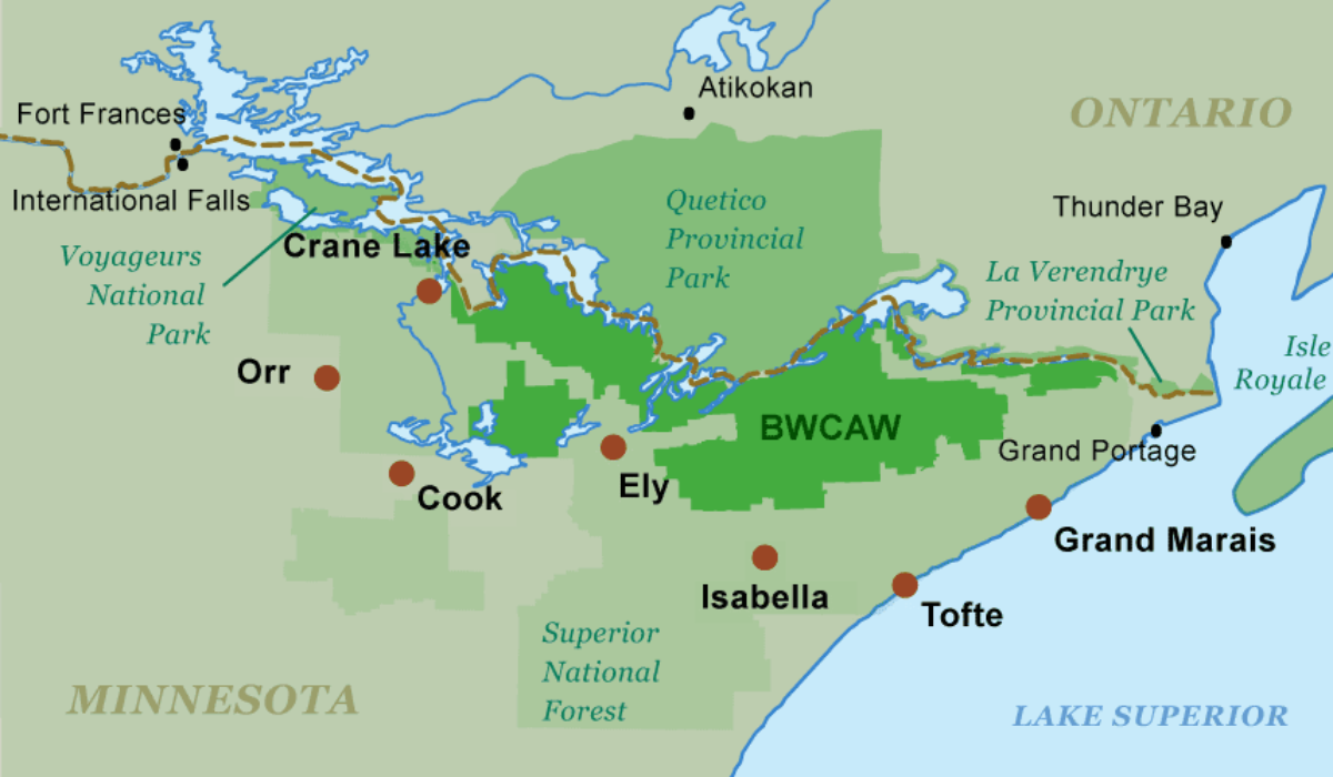
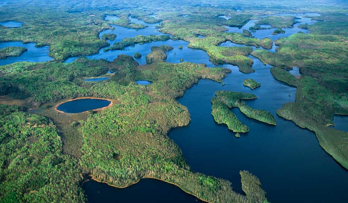
Exploring the BWCAW – 11/3/19

Back in the mid-90s I visited the Boundary Waters Canoe Area Wilderness (BWCAW) for the first time. It was me and 3 other guys, during a record-setting hot summer, canoeing and portaging and fishing and swimming and stargazing — that trip remains one of my favorite lifetime memories! One of the many things I learned from that trip is that you simply cannot navigate that endless wilderness without good map skills. You couldn’t rely on your smartphone’s map app back then (and even if you had one, there is no signal up there), you had only your paper map and a compass. Oh, the joys of orienteering! (Orienteering is a collection of sports that requires navigational skills and tools, such as a map and compass, to navigate from point to point). Since that first trip I returned two more times to BWCAW, in spring and again in fall. I really wanted to experience this wilderness in different seasons, and each trip was a new thrill! The maps of this region are very detailed and complex, and I kept them to remind me of those fond memories. If you’re looking for a true wilderness adventure, I highly recommend Cliff Wold’s Outfitting […]
Read More ›

The Seventeen Miles Drive – 11/2/19

Few artistic legacies are more interesting than that of Joseph Jacinto “Jo” Mora (1876−1947). Mora’s artistic gifts range over a wide variety of mediums, including drawing, painting, illustration, cartooning, sculpture, photography, map-making, and writing. Such diversity is an amazing accomplishment for one person! [Source: Jo Mora Trust]  Mora is probably best known publicly for the series of maps – or cartes, as he referred to them – that he created. These historically accurate, humorous, and collectable prints have entertained viewers for years. One of his most famous maps is a homage to Carmel, the Carmel-By-The-Sea carte. Printed in 1942, it  highlights much of the colorful history of the town. Prints of his maps are available for purchase at New World Cartographic.com. The Seventeen Miles Drive was commissioned in 1927 by the Del Monte Company to advertise its 17 Miles Drive area, and other attractions on the Monterey Peninsula. (The 17-Mile Drive is a scenic road through Pebble Beach and Pacific Grove on the Monterey Peninsula in California, much of which hugs the Pacific coastline and passes famous golf courses, mansions and scenic attractions, including the Lone Cypress, Bird Rock and the 5,300-acre Del Monte Forest of Monterey Cypress trees). A […]
Read More ›

Weird and Wonderful Wisconsin – 10/26/19

I had the great pleasure of meeting Frank Anderson this past weekend. Frank is an animator, director, author, musician, painter and live action filmmaker. He’s an awesome storyteller as well! He was born on Basilan Island in the Philippines but his family has roots in Wisconsin. After moving to Deerfield, Wisconsin at age 11,  he was struck by the many strange and fascinating folklore tales he heard and read about. He collects and shares these stories on his website, Wisconsinology.com, Here you can learn about the origins of monsters and mythology within Wisconsin. His spooky stories range from the Wendigo to the Hodag, the Man-Bat to the Thunderbird, the Ridgeway Phantom and the Mineral Point Vampire. Frank designed a map, called Wisconsin Monsters, Myths and Legends, which features over 60 hand-painted vignettes of petroglyphs, ancient burial mounds, effigy mounds, lost treasure sites, ghost ships and much more. It’s a fun and engaging poster that beckons you to investigate more. For a Wisconsinite like me, it’s a history lesson about my home state that I never got in school. Thanks, Frank!
Read More ›

Monochrome Mapping – 10/19/19

Daniel Huffman is a Madison, Wisconsin-based cartographer who operates a blog called somethingaboutmaps. He recently hosted a monochrome mapping competition, dubbed Mono Carto 2019. He writes, “I love working in monochrome (and gave a talk about it at the NACIS Conference in 2018). I think color is overused, and the challenges of a limited palette can be liberating. I want to draw more attention to the great work that mapmakers are doing in this medium, and encourage more people to experience the joy of composing with only one ink.” There were over 150 entries from across the globe, and they are truly a pleasure to look at! Check out the Final Selections in hi res here.
Read More ›

Best Online Map Collections – 10/14/19

Living in a hyperdigital age has distinct advantages for map lovers: you can view thousands of digitized maps online, anytime! Search by name, year, category, type, location, whatever you like. There are so many online map libraries to choose from, I’ve compiled a list of my favorites here. Enjoy!
Read More ›

4,000 hours of North America – 10/13/19

“Anton Thomas is a New Zealand-born, Melbourne-based artist and cartographer who’s been drawing a massive pictorial map of North America since 2014. His fascination with North America knows no bounds. Actually, scratch that, it knows these bounds: four years, 4,000 hours, three trips across the Pacific, and 47 by 59 inches of paper, covered with a painstakingly hand-drawn map of the continent that he says captured his “geographic heart.” “Drawing this map would be my love letter to a continent. I wanted to share my appreciation for its geography with everyone else, in a way that would encourage geographic curiosity in people regardless of their interest in the topic. I felt that this style of hand-drawn map might be a good way to articulate geography to everyone—from the layperson to the cartographer.” [Source: CityLab.com]
Read More ›

Transforming America – 9/6/19

I recently visited the Boston Public Library and was fortunate to encounter the Norman B. Leventhal Map & Education Center which was presenting a huge exhibit titled “Transforming America: Mapping the 19th Century.” The exhibit is being staged in two parts. The first is called The United States Expands Westward and will be on display until November 2019. Part Two is called “Homesteads to Modern Cities, 1862-1900″ and will be on display Nov. 12, 2019 until May 10, 2020. If you are in Boston during these times I highly recommend stopping in to see all the maps they have collected and curated for this exhibit, it’s extraordinary! The exhibit is free and open to the public. Be sure to allow at least an hour to read and examine all of the displays!
Read More ›

Groovy 70s Map of My Hometown! – 8/6/19

Sometime back in the psychedelic day of bell bottoms, shag carpeting and Bee Gees disco, a poster “was commissioned by Mutual Savings Bank of Wisconsin which depicts “Mutual Savings Country”—a.k.a. Milwaukee, Southeast Wisconsin, and beyond. The artists’ names (located in the bottom-right corner) are Patty Ortega and Darrel Millsap. We can’t find any information on Ortega, but Millsap was a prolific, California-based, Mad Men-era commercial illustrator who died in 2012. (Read more about Millsap and his work here.) There’s no year on the Wisconsin poster, but Millsap created a similar California poster for Home Federal Savings Bank in 1973. [Source: MilwaukeeRecord.com]
Read More ›

Map of Chicago, Pop. 350 – 7/25/19

It was sometime in the middle of 1833 that Rev. J. M. Peck declared, “Chicago is destined to outstrip every other town in the State.” At that time, the population of the future metropolis was only 350! A hundred years later, in 1933, a pictorial map (first photo) was drawn to revisit those earlier days, when Chicago’s population was roughly 350, and highlight some scenes from 19th-century life. Walter H. Conley, an architect and draftsman spent two years sifting through local libraries and archives to bring the cartographic scene to life. An 86-year-old print of the illustration is currently for sale through Geographicus Rare Antique Maps. [Source: AtlasObscura.com] Second photo: A map from 1933, depicting the Chicago of 1833. Courtesy of David Rumsey Map Collection/Public Domain
Read More ›

Map of Ingredient Sourcing – 7/15/19

I recently purchased a 4-pack of Fever Tree Ginger Beer and was surprised to find printed, on the inside of the package, an illustrated map! It shows the source of the ingredients used in the company’s beverages. The map uses a very simple line art style to point out the origin of various ingredients like ginger (Nigeria), Angostura Bark (South America), Lemon (Sicily) and Cassia (Indonesia). Very cool to see maps being used in product packaging. And in this case, educating the consumer in what they are purchasing (and ingesting)!
Read More ›

The World Is A Cat – 6/24/19

I saw this recently as a T-Shirt design and I couldn’t stop laughing!
Read More ›

Maps from Maryland – 6/20/19

I just returned from a great trip out East, to visit family in Maryland. I visited downtown Washington, D.C. and Annapolis and enjoyed every minute. One of my favorite moments was enjoying fresh blue crab at Pusser’s on the docks of Spa Creek and Annapolis Harbor.  While walking around I was pleasantly surprised to see lovely illustrated maps everywhere I went! Here are just a few that I encountered. So many styles! It’s exciting to see illustrated maps so visible and prominent in public areas and stores. Seeing these gave me some ideas for creating my own map (sometime in the near future)!
Read More ›

Vintage Trip Planning Map – 5/23/19

“For adventurous road-trippers of the 1960s, this map produced by General Drafting would have been their ultimate guide. This vintage map from 1962 is filled with full-color illustrations of landmarks and products from each of the fifty states. Prints can be purchased online for travel nerds to hang on their walls at home—or to fold up and keep in their glove compartments. ” [Source: MentalFloss.com]
Read More ›

WWI Maps and Posters – 5/2/19

Last night I attended a special event — “Art, War & Peace: Celebrating a Major Gift of French WWI Posters from the Van Alyea Family to the American Geographical Society Library at the UWM Libraries.” The original posters were exquisite and the talks by former Alliance Française de Milwaukee president Mary Emory and UWM Professor of History Neal Pease were engrossing! There were many maps on display as well, including: a map of new boundaries in Europe as established by the 1919 Peace Conference, a map of population density throughout Europe in 1919 and examples of topographic, thematic and political maps of the same time.   
Read More ›

Wacky Wonders of New York – 3/18/19

Nils Hansell was a New Jersey-born cartographer in the 1950s who created a pictorial map he called “Wonders of New York.” In it he sketched out 300 unique and outrageous attractions and diversions, from Manhattan’s southern tip up to 96th Street. Around the outside of the map is a detailed border hilariously fun illustrations and labels to each of the points of interest. “Hansell’s map is essentially selling the idea of Manhattan as the place to be. It captured the borough’s buzz, Hornsby writes, in the form of the ‘gleaming modernist skyscrapers and the new United Nations building, trans-Atlantic liners, and newly introduced jet passenger planes.’ On a block-by-block level, though, those emblems take a back seat to the smaller sights that have always made the city deliciously, deliriously strange.” [Source: AtlasObscura] This map appears on the cover of Stephen J. Hornsby’s excellent book, Picturing America: The Golden Age of Pictorial Maps (University of Chicago Press, 2017).
Read More ›

Maps of the National Trail System – 3/10/19

America’s National Trails System celebrated 50 years in 2018. It consists of 11 National Scenic Trails, 19 National Historic Trails, and almost 1,300 National Recreation Trails. The Pacific Crest Trail and the Appalachian Trail were our nation’s first National Scenic Trails. I’ve been fortunate to hike some of the PCT but have yet to explore the AT. Check out this comprehensive map of all the trails here. Our National Scenic and Historic Trails total more than 55,000 miles and link 70 wildlife refuges, 80 National Parks, 90 Bureau of Land Management areas, 90 National Forests, 123 Wilderness Areas, and 100 major metropolitan areas. More than 230 million people live within 60 miles of a National Trail. [Source: pcta.org]
Read More ›

Maps from Stories, Stories from Maps – 3/26/19

I am in the middle of an excellent book of literary maps — maps drawn by authors, or others, that introduce or accompany works of fiction. The book is titled, The Writer’s Map: An Atlas of Imaginary Lands. It is edited by Huw Lewis-Jones but is comprised of over 20 chapters, each written by an author or illustrator. “This exquisitely crafted and illustrated atlas explores many of the maps that adorn the writer’s landscape — some real, some imagined — in both words and images.” As examples, see the images rotating here: there is hand-drawn map on the endpages of Steinbeck’s classic, Travels with Charley; the 1934 map of Amtor (Venus) drawn by Edgar Rice Burroughs for his Amtor/Venus series of novels; and the famous map of Treasure Island from his 1894 novel of the same name. One of my favorite passages in this book comes from  the chapter “Rebuilding Asgard” written by English author Joanne Harris. She writes, “What drives us to explore our world? Why do we tell stories? The reason for both is largely the same. We do these things because we want to know what lies beyond the horizon — in writing terms, what happens next. […]
Read More ›

For Sale: A Marvelous Menagerie – 3/20/19

Abraham Orelius was an Antwerp-born mapmaker who was among the first to chart Iceland’s geography in considerable detail. Named Islandia, this artful rendering of this northern island nation is chock-full of mythical beasts, like the Nahval, the Steipereidur, the Skautuhvalur, the Staukul and the Hroshualur. “Most of the sea monsters reflect an effort on the part of the cartographer to be accurate int he depiction of what lived in the sea.” A 1603 edition of Islandia is up for sale at Swann Auction Galleries, where dealers expect it to fetch between $3,500 and $5,500.[Source: AtlasObscura]
Read More ›

Follow the Map to Great Wine – 3/11/19

I was looking for a bottle of wine the other day and, as you might expect from a visual artist like myself, I was appreciating some of the great bottle labels on the shelf. This one caught my eye, for one obvious reason — the map! I picked it up and saw that it was from a Washington state vineyard (one of my faves). BOOM! I bought the bottle on sight and enjoyed a glass with my dinner that night. Delicious! Boomtown by Dusted Valley was founded by in 2003 by Wisconsin natives Chad Johnson and Corey Braunel (what a small world!). “They left the comforts of their corporate jobs to move to Walla Walla and fulfill their dream of crafting world-class wine.” From the back label: “We set out with nothing more than a blank map, an unquenchable thirst for adventure and a natural sense of direction — and ended up with a wine to write home about.” The vintage, hand-drawn quality of the map on the deckled-edge label sure does hint at timeless adventure in a far-away land and beckons me to learn more. And as any educated oenophile knows, terroir (how a particular region’s climate, soils and […]
Read More ›

Honoring Women Around the World – 3/8/19

Today is International Women’s Day, a focal point for women’s rights around the world. It is a cause for protest in some countries, a reason to celebrate womanhood in others. On this day it is customary for men to give the women in their lives – friends, mothers, wives, girlfriends, daughters, colleagues, etc. – flowers and small gifts. [Source: Wikipedia.com]. Here is a beautiful map by the talented Dearbhla Kelly that honors female Irish inventors, social reformers, artists, scientists, a pioneering aviator and a mountaineer. “There could have been so many more. With one exception, all the women in our list are no longer with us, but all deserve to be celebrated and remembered into the future.” Click here to view the map and read more about these 40 remarkable women.
Read More ›

Map Oddities – 3/1/19

“Maps are a fascinating intersection of culture, politics, geography, history and art.” This was the sentiment offered during an excellent lecture I recently attended, sponsored by The Map Society of Wisconsin at the American Geological Society on the UW-Milwaukee campus. Guest speaker Chuck Olsen is a retired Lieutenant Colonel with 21 years of service in the U.S. Army. He has visited 30 countries and has a lifelong passion for cartography and cultural geography. He also collects globes! Chuck presented “17 Fascinating World Map Oddities.” The world of maps and cartography is riddled with weird and wacky stories and Chuck brought them to life by using anecdotes from his personal travels. His presentation at times reminded me of a game show, as he enjoyed quizzing the audience about each “oddity.” Such as, “Where in North America is there a territory of France?” (Answer: Saint Pierre et Miquelon, an island off the southern coast of Newfoundland) and “Where is the world’s only international quadripoint? (Answer: in the middle the Zambezi River in Southern Africa, where Namibia, Zimbabwe, Zambia and Botswana all meet at a single point). Thanks for an entertaining and informative lecture, Chuck!
Read More ›

Kiss Me, I’m Irish! – 2/27/19

Rummaging through a desk drawer recently, I came across a tattered manila folder full of genealogical documents, assorted photocopies and hand-written scribbles I made during a conversation with my late grandmother Lucille. It had become buried and forgotten — much like the memories of my family’s past. I don’t know why it’s taken me so long to organize them into a family tree. I guess it’s partly because it’s a daunting project, and the busyness of life got in the way. But I’ve been enjoying the investigative process of tracing back the various branches of my family, getting to better know the lives of distant aunts and uncles and grandparents whose names I barely recognize, but all of whom had a role in making me the person I am today. One of the more exciting discoveries I made is: I have Irish roots! I was thrilled to learn that I have relatives (5 to 6 generations ago) from the Gallagher (Donegal County) and Murphy clans (Wexford County). How cool is it to know this right before St. Patrick’s Day! There are many maps of Irish surnames out there (one was hanging near the entrance of my local Irish pub!), which […]
Read More ›

Edible Maps – 2/5/19

Imagine a map of Italy that not only depicted all of its wonderful regional foods…but it was also edible! Rose Mackean, chef and food stylist at Travel Supermarket.com was inspired to create such a map, of Italy, Spain and Greece. Yum! Click here to see the tasty maps in all their glory. There’s a great video of Rose’s process as well.
Read More ›

The Map House – 2/4/19

The Map House is London’s oldest specialist antiquarian map seller. Founded in 1907 as Map and Booksellers, they have been selling maps to collectors, motorists, aviators, explorers, Prime Ministers and the Royal Family for over a century! They have supplied maps of Antarctica to Ernest Shackleton, the Far East to Winston Churchill, and the Western Front to Edward VIII. “Our enormous stock covers every part of the world reflecting the changing face of cartography over a period of half a millennium. From the tentative groping for knowledge of the German masters to the elegance of early Italian copper engraving; from the magnificent flowering of seventeenth century Dutch cartography to the flamboyant baroque decoration of the eighteenth century; from charming English rococo to the sober Age of Reason – illustrative style is represented in all its beauty and diversity.” [Source: TheMapHouse.com] You will find The Map House offers so much more than maps. For example, check out their travel posters, it’s a blast to browse their collection!  
Read More ›

Murder Maps – 2/1/19

I just discovered a series on Netflix called Murder Maps (OK, I admit, the “Maps” got my attention right away!). “The series transports us to the Victorian era and beyond to learn about some of England’s most notorious and intriguing murder cases. Host Nicholas Day revisits the locations of diabolical crime scenes, introduces us to the perpetrators and their victims, as well as the newly-created Metropolitan Police and the field of crime-fighting called forensics — clevernew techniques that helped them solve these often gruesome crimes.” Last night I watched Episode 1 of the first season titled “The Bermondsey Horror” and found it to be a bloody good show! I really like Day’s narrative style and the re-enactments were smashing! In each episode, maps take the viewer to the various scenes of the crimes and help orient us to 1800s London. If you like maps, history, crime dramas and a cracking good detective story, I think you’ll really enjoy Murder Maps.
Read More ›

Trail Maps are Cool! – 1/29/19

It may have been snowing sideways with sub-zero windchills, but here in Wisconsin our winter has been unusually snow-free. So I grabbed my snowshoes and hit the trail at my local Greenfield Park. I am familiar with this park and ride the mountain bike trails there often…but the deep snow yesterday made finding my way a bit more tricky. I was pretty happy to see the park maps were still posted!
Read More ›

Wearable Maps – 1/27/19

“True North Map Company is the passion of Jerod Arlich and Joe Spadino, local Boundary Water Enthusiasts, who have spent thousands of hours in canoes and on portage trails. They understand the importance of navigation and the need to have the map fully accessible to follow along with the contours of the lake and checking off landmarks such as campsite and island as you go and wanted a map that didn’t need to be confined to a case. So they did. True North Map Company produces maps that can be worn, stuffed, washed, written on and used over and over again. A map that is now up to the rigors of a BWCA trip.” “Combining the most accurate GIS data, with microfiber flexibility, Joe and Jerod have created a fabric map that is wearable, durable, and functional for a wilderness adventure.” Though I think I would rather navigate with the reliable paper (coated to be rip-proof and waterproof) maps, this is still a novel idea. I’ve been anxious to make it back to the BWCAW for my 4th trip so maybe I’ll place an order and give it a try!
Read More ›

REI Parks Project T-Shirts – 1/24/19

I recently these excellent illustrated map T-shirts at my local REI store (click here for purchase info). One displays the national parks of Colorado, another the parks of Washington. I especially liked the one of the Appalachian Trail. The AT — from Springer Mountain, Georgia in the south to Mount Katahdin, Maine  in the north — extends for 2,200 miles and crosses through 14 states. It is one of the longest hiking trails in America and is one of the Triple Crown of Hiking (the others being the Pacific Crest Trail and the Continental Divide Trail). Hikers typically reserve 4-7 months to hike the AT, though it has been done in as little as 50 days. Click here for more information on the AT.
Read More ›
error: Content is protected!